

By Roger Coppock
January 17, 2015 (San Diego’s East County)--NASA's Goddard Institute For Space Studies has reduced global temperature data from the National Oceanic and Atmospheric Administration. Their "GISS Analysis" uses satellite measurements of night lighting to locate population centers. GISS uses this population map to statistically remove the artificial warming of cities, known as the "Urban Heat Island Effect," or UHI, from the NOAA's ground station data. In the opinion of this author, that correction makes the NASA GISS's data the most reliable estimate of the near surface temperature of our planet. Please see:
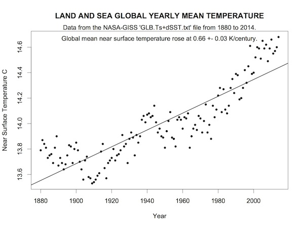 The 15 warmest years according to NASA GISS:
Year MeanTemp
1 2014 14.68
2 2010 14.66
3 2005 14.65
4 2007 14.62
5 1998 14.61
6 2002 14.60
7 2013 14.60
8 2003 14.59
9 2006 14.59
10 2009 14.59
11 2012 14.57
12 2011 14.55
13 2001 14.52
14 2004 14.51
15 2008 14.49
NOTES:
The global yearly mean near surface land and sea temperature record is found in the column labeled "AnnMean" and "J-D" in the file at the URL below.
http://data.giss.nasa.gov/
The data file was sampled on 1/16/15 and includes all 12 months of data for the year 2014.
These data are part of the "GISTEMP" product from NASA's Goddard Institute For Space Studies. The GISTEMP process corrects NOAA temperature data for UHI, the Urban Heat Island effect, by using satellite observations of artificial night lighting to estimate the locations of urban and rural areas. Please see:
http://data.giss.nasa.gov/


Recent comments