
September 5, 2013 (San Diego’s East County) – The National Weather Service has issued a severe weather statement covering all of East County and San Diego, along with warnings of severe thunderstorms, flash flooding and high winds occurring now in rural and mountain areas.
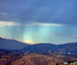
At 2:30 p.m., NWS Doppler radar indicated a severe thunderstorm capable of producing quarter-size hail and destructive winds in excess of 70 miles per hour. It was spotted near Santa Ysabel and Julian, moving northwest along Highway 79 toward Cuyamaca State Park and the Cuyamaca Peak.
Flash flooding is also occurring in Palomar Mountain and Cuyamaca State parks as well as for dry washes in the Descanso, La Posta, Cottonwood, Kitchen Creek and Rattlesnake areas. These areas are receiving one to three inches of rain, as well as strong, gusty winds. A reader reports wind gusts of 44 mph in Guatay.
SDG&E reports power poles and trees are down near Pine Valley. An outage is reportedly affecting 60 customers in Guatay, Pine Valley and Mount Laguna communities.
Sign up to receive free Viejas Wildfire & Emergency Alerts via email at the top right side of our homepage, and also receive a free weekly copy of East County Magazine. You can also follow ViejasAlerts on Twitter for brief text alerts on your mobile phone. We recommend all of the above since you don't know what form of communication will work best in a major regional emergency. Stay safe! Sign up to receive alerts at home, at work, at school and on the road.


Recent comments