San Diego weather

RED FLAG WARNING ISSUED FOR HIGH FIRE DANGER


East County Wildfire and Emergency Alerts


October 8, 2017 (San Diego’s East County) -- The National Weather Service has issued a red flag warning for all of inland San Diego County as medium to strong Santa Winds bring very dry and windy weather to our region starting tonight through early Tuesday.  Critical fire weather conditions are likely in parts of coastal foothills, valleys and mountain passes.

Northeast winds of 25 to 35 miles per hour with gusts up to 55 miles per hour are forecast. This could bring power outages, broken tree limbs and debris on roadways as well as hazardous cross-winds for high-profile vehicles, so use caution if traveling.


Error message

Support community news in the public interest! As nonprofit news, we rely on donations from the public to fund our reporting -- not special interests. Please donate to sustain East County Magazine's local reporting and/or wildfire alerts at https://www.eastcountymedia.org/donate to help us keep people safe and informed across our region.

TROPICAL STORM LIDIA COULD BRING THUNDERSTORMS, ROUGH SEAS TO SAN DIEGO COUNTY THIS WEEKEND


East County News Service

September 1, 2017 (San Diego’s East County) – If you’re  planning a picnic, barbecue or other outdoor activity this Labor Day weekend, be aware there’s a possibility of widespread showers and scattered thunderstorms due to tropical storm Lidia.

Tropical Storm Lidia has already wreaked havoc in Baja, Mexico, bringing flooding in Cabo San Lucas and closing airports at Cabo and La Paz. Some 20,000 tourists and thousands of residents have been evacuated to shelters there.


Error message

Support community news in the public interest! As nonprofit news, we rely on donations from the public to fund our reporting -- not special interests. Please donate to sustain East County Magazine's local reporting and/or wildfire alerts at https://www.eastcountymedia.org/donate to help us keep people safe and informed across our region.

RESIDENTS SWELTER--AND FROLIC--AS STORM DOUSES REGION


By Miriam Raftery

Photo: East County resident Linda Niman stripped down and cooled off with a free-spirited "rain dance" that piqued interest on social media.  

August 3, 2017 (San Diego’s East County) – A monsoonal storm brought torrential rain, hail, lightning strikes and flooding to portions of San Diego County over the past two days.

Residents also sweltered in high heat coupled with high humidity  The National Weather Service San Diego office posted on Facebook earlier today,“Current Dewpoint at the office is 73F degrees, oppressive!"


Error message

Support community news in the public interest! As nonprofit news, we rely on donations from the public to fund our reporting -- not special interests. Please donate to sustain East County Magazine's local reporting and/or wildfire alerts at https://www.eastcountymedia.org/donate to help us keep people safe and informed across our region.

FLOOD WATCH FOR EAST COUNTY AND INLAND AREAS


East County Wildfire & Emergency Alerts

August 2, 2017 (San Diego’s East County)   -- The National Weather Service has issued a flood watch Wednesday morning for San Diego’s inland region that includes the East County communities of La Mesa, El Cajon, Santee, Pine Valley and Julian as well as other inland areas of Escondido, Poway and San Marcos. 

The flood watch is in effect through tonight, with the threat of flash flooding and debris flows greatest in areas burned bare by brush fires. A deluge could bring over an inch an hour to some areas.


Error message

Support community news in the public interest! As nonprofit news, we rely on donations from the public to fund our reporting -- not special interests. Please donate to sustain East County Magazine's local reporting and/or wildfire alerts at https://www.eastcountymedia.org/donate to help us keep people safe and informed across our region.

FLEX ALERT: ALL CALIF. RESIDENTS ASKED TO CONSERVE POWER TODAY FROM 2 TO 9 PM

Twitter


East County News Service

June 20, 2017 (San Diego)—California residents are asked to save power from 2 to 9 p.m. by turning off unnecessary lights and appliances and setting air conditioning to turn on at 78 degrees or higher. The Flex Alert, issued by the Califiornia Independent Systems Operator that manages the power grid, aims to prevent blackouts during high power demand periods.


Error message

Support community news in the public interest! As nonprofit news, we rely on donations from the public to fund our reporting -- not special interests. Please donate to sustain East County Magazine's local reporting and/or wildfire alerts at https://www.eastcountymedia.org/donate to help us keep people safe and informed across our region.

SPRING STORM COULD BRING SNOW THIS WEEKEND


By Miriam Raftery

May 4, 2017 (San Diego’s East County) – A late spring storm will bring gusty winds, rain and snow as low as 4000 feet this weekend, the National Weather Service advises

Starting Saturday afternoon, expect strong winds, with blowing dust and sands in desert areas producing hazardous driving conditions in some areas.


Error message

Support community news in the public interest! As nonprofit news, we rely on donations from the public to fund our reporting -- not special interests. Please donate to sustain East County Magazine's local reporting and/or wildfire alerts at https://www.eastcountymedia.org/donate to help us keep people safe and informed across our region.

EXTREME FLOODING SOAKS REGION


Report rock slides, boulders or other dangerous road conditions to the County Operations Emegency Call Center (858)565-5262. Help save lives!

By Miriam Raftery

Photos by Christina Dahners-Johnson:  Seasonal creek behind Lyons Valley Trading Post in Jamul had been dry for at least seven years before this storm.

February 27, 2017 (San Diego) – Flooding is wreaking havoc on rural roads and highways countywide.  In Mission Valley, the San Diego River has water cresting among the top 10 levels on record, with the ballfield at Petco Park and some parking garages currently submerged.

George Barnett, a member of the Alpine Community Planning Group, posted in the Ranter’s Roost forum, “ It’s raining like hell in Alpine…Viejas Creek is way outside   its normal channel and Via Viejas into the old ranch area is closed with the dam well over-flowing.  To my eye, on a dark and cloudy day, more water is coming down the creek than I recall seeing in maybe 10 years.”


Error message

Support community news in the public interest! As nonprofit news, we rely on donations from the public to fund our reporting -- not special interests. Please donate to sustain East County Magazine's local reporting and/or wildfire alerts at https://www.eastcountymedia.org/donate to help us keep people safe and informed across our region.

FLASH FLOOD WATCH ISSUED


February 27, 2017 (San Diego)--The National Weather Service has issued a Flash Flood Watch for the coast, valleys and mountains of San Diego County below 5000 feet for late this morning into this evening.

A low pressure system from the northwest will tap a plume of subtropical moisture directed into northern Baja to bring periods of locally heavy rainfall from late this morning into early this evening. The most significant rainfall is expected from central and southern San Diego County into northern Baja.


Error message

Support community news in the public interest! As nonprofit news, we rely on donations from the public to fund our reporting -- not special interests. Please donate to sustain East County Magazine's local reporting and/or wildfire alerts at https://www.eastcountymedia.org/donate to help us keep people safe and informed across our region.

ROAD HAZARDS ACROSS REGION, SNOW IN MOUNTAINS, FROST WARNING TONIGHT IN URBAN AREAS


East County Wildfire & Emergency Alerts

December 24, 2016 (San Diego's East County)--Heavy snow is blanketing Mt. Laguna, with several inches reported in Boulevard.  Snow could dip to 3,000 feet tonight, with frost possible even in urban and suburban areas such as El Cajon and La Mesa tonight and tomorrow, according to forecaster Alex Tardy with the National Weather Service.

The storm, combined with accidents, has resulted in numerous accidents and other road hazards across our region.


Error message

Support community news in the public interest! As nonprofit news, we rely on donations from the public to fund our reporting -- not special interests. Please donate to sustain East County Magazine's local reporting and/or wildfire alerts at https://www.eastcountymedia.org/donate to help us keep people safe and informed across our region.

WHITE CHRISTMAS: SNOW FORECAST DOWN TO 3,500 FEET


Sheriff warns of snow jams

Readers, send us your snow photos! editor@eastcountymagazine.org

East County News Service

December 22, 2016 (San Diego’s East County) – A winter storm in the region is dropping heavy rain across our region, with snow forecast to dip down to 3,500 feet by Saturday. That includes Pine Valley, Descanso,  and Julian,  with  six inches or more possible atop Mt Laguna.

Strong winds of 60 miles per hour or more are expected in some mountain areas.

The Sheriff offers this advice if you plan to visit these areas:


Error message

Support community news in the public interest! As nonprofit news, we rely on donations from the public to fund our reporting -- not special interests. Please donate to sustain East County Magazine's local reporting and/or wildfire alerts at https://www.eastcountymedia.org/donate to help us keep people safe and informed across our region.

STORMS SOAK REGION; HIGH WIND WARNING ISSUED

By Miriam Raftery

Photo:  UCSD HP Wren camera on Mt. Laguna

November 27, 2016 (San Diego's East County) --The National Weather Service has issued a high wind warning for our mountain and desert regions through tonight,with gusts up to 65 miles an hour possible.  If traveling watch for downed trees and power lines, blowing sand, rain-slicked highways and icy conditions in higher mountain areas.

Drought-parched mountain areas in East County have received welcome relief from a pair of storms that swooped into the region over the weekend.

As of 12:30 p.m. on Sunday, the National Weather Service reports over 2.4 inches of rain fell at Lake Cuyamaca, with nearly 1.7 inches at Julian. Snow has fallen on taller mountain peaks, including over an inch on Mount Laguna.


Error message

Support community news in the public interest! As nonprofit news, we rely on donations from the public to fund our reporting -- not special interests. Please donate to sustain East County Magazine's local reporting and/or wildfire alerts at https://www.eastcountymedia.org/donate to help us keep people safe and informed across our region.

RED FLAG WARNING FOR FRIDAY AND SATURDAY


Source: County Emergency Services

September 1, 2016 (San Diego's East County) --The National Weather Service has issued a Red Flag Warning from 11 a.m. Friday to 8 p.m.Saturday for the San Diego County mountains and deserts. The Red Flag Warning has been issued due to strong gusty winds and low humidity.

Winds will be west to southwest 15 to 25 miles per hour with gusts to 40 mph. Strongest winds will be in the afternoon and evening with afternoon humidity forecasted at 5 to 10 percent.


Error message

Support community news in the public interest! As nonprofit news, we rely on donations from the public to fund our reporting -- not special interests. Please donate to sustain East County Magazine's local reporting and/or wildfire alerts at https://www.eastcountymedia.org/donate to help us keep people safe and informed across our region.

RED FLAG WARNING, HEAT ADVISORY


East County News Service

August 15, 2016 (San Diego’s East County) – A red flag alert for high fire danger has been issued for the mountain and desert areas in East County due to hot, dry,windy conditons through Friday. In addition, a heat advisory is in effect for inland regions in our county due to triple digit temperatures today.


Error message

Support community news in the public interest! As nonprofit news, we rely on donations from the public to fund our reporting -- not special interests. Please donate to sustain East County Magazine's local reporting and/or wildfire alerts at https://www.eastcountymedia.org/donate to help us keep people safe and informed across our region.

EXTREME HEAT WARNING-- AND COOL ZONE LOCATIONS


Update: See our list of fun places to cool off that aren't on the county's list of cool zones -- we found bowling alleys, ice rinks, theaters, malls, casinos, splash parks and more,plus tips on how to coll down at home:http://www.eastcountymagazine.org/more-places-cool-sunday

Flex power outages are possible, SDG&E warns, so be prepared!

East County News Service

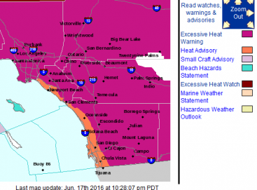
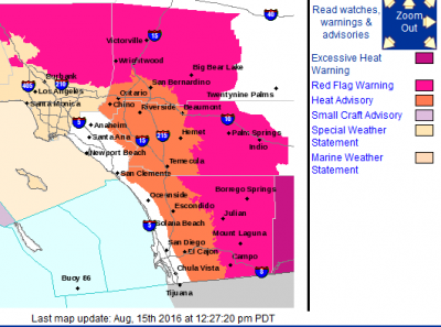
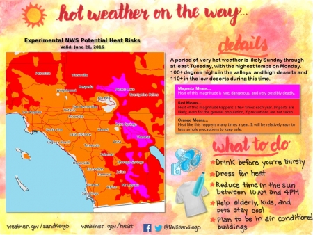
June 17, 2016 (San Diego's East County) -- Extremely high temperatures forecast for the valleys, mountains, and desert areas of San Diego County have prompted the National Weather Service to issue an excessive heat warning.  The warning is in effect from 11 a.m. Sunday, June 19th, through 8 p.m. Wednesday, June 23rd across our county.  Temperatures could reach 25 degrees higher than normal in some locations, with deserts hitting 120 degrees and many inland areas in triple digit temperatures.

The County operates a Cool Zones program and has designated more than 115 air-conditioned buildings as cooling centers.  For a complete listing of Cool Zone locations, see the Emergency Map. Additionally, the following two Cool Zones have extended hours for Sunday 11 a.m. – 5 p.m. and Monday 10 a.m. – 6 p.m.:

  • Borrego Springs Library, 587 Palm Canyon Drive, Suite 125
  • Potrero Library, 24883 Potrero Valley Rd.

Error message

Support community news in the public interest! As nonprofit news, we rely on donations from the public to fund our reporting -- not special interests. Please donate to sustain East County Magazine's local reporting and/or wildfire alerts at https://www.eastcountymedia.org/donate to help us keep people safe and informed across our region.

HEAT WAVE TO ARRIVE THIS WEEKEND


East County News Service


June 14, 2016 (San Diego's East County) -- Very hot and potentially dangerous conditions are forecast for Sunday through the early part of next week as a strong ridge of high pressure develops over the Southwest. Monday is expected to be the hottest day, the National Weather Service in San Diego predicts.

Highs near the coast will be in the upper 80s to low 90s, in the 90s in the mountains, around 100 to 110 in the valleys and high desert, and over 115 in the low deserts.


Error message

Support community news in the public interest! As nonprofit news, we rely on donations from the public to fund our reporting -- not special interests. Please donate to sustain East County Magazine's local reporting and/or wildfire alerts at https://www.eastcountymedia.org/donate to help us keep people safe and informed across our region.

WINTER STORM BRINGS SEVERE THUNDERSTORMS, SNOW TO REGION


East County News Service

March 7, 2016 (San Diego's East County)--A strong line of thunderstorms will continue across the area this morning. Brief, heavy downpours, dangerous lightning, gusty winds, small hail and slick roads are expected this morning. The snow level could drop to 4,000 feet tonight, with several inches of snow above 4,500 feet.

There is also a special marine warning that includes all coastal waters in San Diego County due to severe thunderstorms. Boaters are advised to move to shore until the storm passes.


Error message

Support community news in the public interest! As nonprofit news, we rely on donations from the public to fund our reporting -- not special interests. Please donate to sustain East County Magazine's local reporting and/or wildfire alerts at https://www.eastcountymedia.org/donate to help us keep people safe and informed across our region.

NOT A TORNADO, BUT “MICROBURSTS” IN YESTERDAY’S STORM CAUSED PLENTY OF DAMAGE

By Miriam Raftery

Photo: fallen tree Jan. 7 in La Jolla, courtesy ECM news partner 10 News

January 7, 2016 (San Diego ) – The tornado forecast to hit north-central San Diego County yesterday didn’t materialize. But “wet microbursts” did cause major wind damage. 

Among the hardest hit communities was the Poway-Sabre Springs area, where damage was “consistent with 60 to 70 mile per hour straight-line winds,” says Alex Tardy, warning coordination meteorologist manager for the National Weather Service in San Diego. Thunderstorm microbursts can be as strong as 100 mph, he added.  Surveys conducted thus far found:


Error message

Support community news in the public interest! As nonprofit news, we rely on donations from the public to fund our reporting -- not special interests. Please donate to sustain East County Magazine's local reporting and/or wildfire alerts at https://www.eastcountymedia.org/donate to help us keep people safe and informed across our region.

MAJOR ROAD CLOSURES AND HAZARDS DUE TO SNOW, FLOODING, AND DEBRIS

January 7, 2016 (San Diego's East County) -- Snow, debris flows and flloding from heavy rainfall are making the morning commute tough. Here are the latest updates on closures and hazards impacting Highway 94, Interstate 8 and other highways as well as major surface streeets across East County.

  • Snow on I-8 just east of Kitchen Creek – snow ploughs are working (CHP)  Numerous accidents reported east of Pine Valley.
  • SR-94 closed both directions from Lyons Valley Rd. to Honey Springs due to flooding (Caltrans); CHP site indicates a “river” flowing 30-40 feet wide this a.m.
  • Sunrise Highway is open but you are required to carry chains. CHP is en route to check conditions on Highway 79 from I-8 to Julian.
  • Dehesa road from the school to willow glen has multiple mudslides and is a total mess.    Willow glen is completely closed by the quarry, a reader reports
  • State Route 94 at Buckman Springs Rd., vehicle overturned (CHP)
  • I-8 east west of Fuerte, off-ramp sign fell down and is in slow lane, per CHP
  • Ramona: B St. closed from 10th and at 11th due to flooding (DPW).  Also Magnolia dip is now closed at highway 78 and 500 feet north of Magnolia dip due to flooding in Ramona.
  • Spring Valley: Quarry Road from SR125 to Lakeview is closed due to flooding(DPW)


Error message

Support community news in the public interest! As nonprofit news, we rely on donations from the public to fund our reporting -- not special interests. Please donate to sustain East County Magazine's local reporting and/or wildfire alerts at https://www.eastcountymedia.org/donate to help us keep people safe and informed across our region.

SAN DIEGO RIVER EXPECTED TO REACH FLOOD STAGE TONIGHT


Flooding and boulders also block roadways in East County; snow impedes travel in mountains

By Miriam Raftery

Photo: Ward Road in Mission Valley, courtesy of San Diego Lifeguards

January 6, 2016 (San Diego) – With yet another storm set to hit tonight, the San Diego River is expected to reach flood stage (11.5 feet) tonight, cresting in the pre-dawn hours.  The National Weather Service reports the river level has risen five feet in the past 24 hours to nearly 8 feet..  Major roads crossing the river in Mission Valley are closed and underwater including Fashion Valley Road, Avenida del Rio, Camino del Este, Camino de la Reina and Mission Center Road.  The San Diego Mission del Alcala church has flooded, as has the parking lot at Fashion Valley mall.

In East County, snow levels could dip down to 4,000 feet tonight, including the Julian area.  Chains are currently required on Mount Laguna/Sunrise Highway from State Route 79 to Highway 8.  There are also numerous closed or obstructed roadways:


Error message

Support community news in the public interest! As nonprofit news, we rely on donations from the public to fund our reporting -- not special interests. Please donate to sustain East County Magazine's local reporting and/or wildfire alerts at https://www.eastcountymedia.org/donate to help us keep people safe and informed across our region.

A WET START TO 2016: STORMS TO SWEEP IN, STARTING SUNDAY

East County News Service

January 1, 2016 (San Diego's East County)--“What could be better than the Rose Parade? How about a parade of storms!” The National Weather Service website in San Diego states on New Year’s morning. Starting late Sunday, the first in a series of storms will move in, bringing light rain across Southern California, with the heaviest rainfall forecast for southern San Diego County.  More storms will bring additional rain throughout the week, with heavy downpours  at times.  Snow is forecast for 4,500 feet elevation and higher.

Watch for blowing snow and dust in the mountain and desert areas.


Error message

Support community news in the public interest! As nonprofit news, we rely on donations from the public to fund our reporting -- not special interests. Please donate to sustain East County Magazine's local reporting and/or wildfire alerts at https://www.eastcountymedia.org/donate to help us keep people safe and informed across our region.

MORE SNOW MAY FALL ON MOUNT LAGUNA


East County News Service

Photo: Mt. Laguna on December 29, 2015, courtesy UCSD's HP WRen webcam

December 30, 2015 (Mt. Laguna)--Visitors flocked to Mount Laguna yesterday after a light snowfall left just enough for sledders to enjoy some winter fun.  A frost advisory is in effect for much of our region tonight through Thursday, with clear skies forecast for New Year’s Eve.

Though warmer weather this weekend is expected to melt away those patches of snow remaining, a new storm expected to hit Wednesday and Thursday of next week could bring more snow to the region, including Julian as well as Mt. Laguna—so keep those snow boots and sleds handy.


Error message

Support community news in the public interest! As nonprofit news, we rely on donations from the public to fund our reporting -- not special interests. Please donate to sustain East County Magazine's local reporting and/or wildfire alerts at https://www.eastcountymedia.org/donate to help us keep people safe and informed across our region.

SNOW, ICY ROADWAYS IN MOUNTAINS


East County News Service

File photo: Snow in Cuyamacas by Grace Schleiser

December 28, 2015 (San Diego’s East County) – A winter storm is bringing snow, ice and fog to our mountain regions.

Chains are required due to icy/snowy conditions on the Julian-Sunrise Highway from State Route 79 to Old Highway 80, according to the County Department of Public Works. Caltrans reports icy conditions on I-8 at Mountain Pass as well as on State Route 76 at Palomar Mountain.

The Laguna Mountain Lodge reports on its Facebook page that snow is falling on Mt.Laguna.  Residents across East County report snow in the Lake Cuyamaca area, an iced over pond in Descanso and cold conditions across our inland region.


Error message

Support community news in the public interest! As nonprofit news, we rely on donations from the public to fund our reporting -- not special interests. Please donate to sustain East County Magazine's local reporting and/or wildfire alerts at https://www.eastcountymedia.org/donate to help us keep people safe and informed across our region.

HIGH WINDS, RAIN AND SNOW TO AFFECT HOLIDAY TRAVEL


East County News Service

December 24, 2015 (San Diego’s East County) – The National Weather Service has issued a high wind warning in effect from Christmas Eve through Christmas morning in San Diego’s mountain and desert regions.  Winds of 35-40 miles per hour with gusts up to 80 mph are forecast. 

A cold front is also moving across the region, bringing rain and snow down as low as 3,000 feet.


Error message

Support community news in the public interest! As nonprofit news, we rely on donations from the public to fund our reporting -- not special interests. Please donate to sustain East County Magazine's local reporting and/or wildfire alerts at https://www.eastcountymedia.org/donate to help us keep people safe and informed across our region.

SNOWY, WINDY WEATHER TO SOCK REGION STARTING TONIGHT

By Miriam Raftery

December 10, 2015 (San Diego’s East County) – A low pressure trough moving south into our region is forecast to bring strong westerly winds, showers and mountain snow tonight through Friday, meteorologist Mark Moede with the National Weather Srevice in San Diego advises.

Wind gusts could reach 60 to 70 miles per hour, posing hazards to high profile vehicles in mountains and deserts, including on I-15, I-8, and I-10.  There is also a chance of thunderstorms, hail and brief, heavy downpours possible.


Error message

Support community news in the public interest! As nonprofit news, we rely on donations from the public to fund our reporting -- not special interests. Please donate to sustain East County Magazine's local reporting and/or wildfire alerts at https://www.eastcountymedia.org/donate to help us keep people safe and informed across our region.

WHITE THANKSGIVING IN EAST COUNTY


East County News Service

November 20, 2015 (San Diego’s East County) – The National Weather Service is forecasting snow Wednesday and Thursday down to 3,000 feet, potentially including I-8 in East County.  Significant levels of snow are forecast above 5,000 feet, bringing a white Thanksgiving to our mountain areas. 

Holiday travelers should use caution due to slippery roads and strong west winds, as well as potential for ice, snow, and of course, wild turkeys!


Error message

Support community news in the public interest! As nonprofit news, we rely on donations from the public to fund our reporting -- not special interests. Please donate to sustain East County Magazine's local reporting and/or wildfire alerts at https://www.eastcountymedia.org/donate to help us keep people safe and informed across our region.

STRONG WINDS, SHOWERS SUNDAY AND MONDAY


East County News Service

November 14, 2015 (San Diego’s East County) –Strong winds across our region are forecast for Sunday afternoon through Monday, with gusts over 70 miles per hour possible on mountain crests and desert mountain slopes and gusts of 35 to 60 mph in mountain and desert areas. 

Gale force wind gusts of 35 to 40 knots are also forecast over coastal waters, says Stephen Harrison, meteorologist with the National Weather Service.

Showers are also forecast, with rainfall light in most areas, though mountains could receive a half inch of precipitation.


Error message

Support community news in the public interest! As nonprofit news, we rely on donations from the public to fund our reporting -- not special interests. Please donate to sustain East County Magazine's local reporting and/or wildfire alerts at https://www.eastcountymedia.org/donate to help us keep people safe and informed across our region.

WIND ADVISORY


November 10, 2015 (San Diego’s East County) – A wind advisory has been issued for San Diego County’s mountains and deserts through 4 p.m. today.

West winds of 20 to 30 miles per hour are forecast with isolated gusts up to 55 miles per hour possible, particularly along mountain ridges and desert slopes.


Error message

Support community news in the public interest! As nonprofit news, we rely on donations from the public to fund our reporting -- not special interests. Please donate to sustain East County Magazine's local reporting and/or wildfire alerts at https://www.eastcountymedia.org/donate to help us keep people safe and informed across our region.

STORM WALLOPS REGION: TRAPS 20 CARS IN FLOODWATERS


By Miriam Raftery

November 4, 2015 (San Diego’s East County) –Last night’s storm brought lightning, thunder and heavy rains across Southern California, bringing welcome relief from drought but wreaking havoc on area highways.  All lanes flooded on State Route 94 near the College exit and vehicles exiting on Federal Blvd. quickly became stuck in rising floodwaters  reportedly up to the hoods – sending some cars afloat, necessitating rescues. ECM news partner 10 News has video shot by one motorist trapped in flooding: http://www.10news.com/news/video-san-diego-couple-trapped-in-floating-car .

The deluge last night fell on already rain-soaked areas from lighter showers earlier in the day. By 1 p.m., over an inch of rain had already fallen in Lemon Grove and many mountain areas, with 1.39 inches recorded at the Pine Hills area near Julian.


Error message

Support community news in the public interest! As nonprofit news, we rely on donations from the public to fund our reporting -- not special interests. Please donate to sustain East County Magazine's local reporting and/or wildfire alerts at https://www.eastcountymedia.org/donate to help us keep people safe and informed across our region.

HEAT ADVISORY ISSUED

East County Alerts

October 11, 2015 (San Diego)--The National Weather Service in San Diego has issued a heat advisory for San Diego County inland coastal and western valley areas from 11 a.m. to 6 p.m. Sunday (today).

Temperatures are expected to range from 90 to 95 degrees for inland coastal areas and 95 to 99 in western valley areas.

The County issued an alert at 10:45 a.m. today. The County continues to operate the Cool Zones program and has designated buildings as cooling centers.


Error message

Support community news in the public interest! As nonprofit news, we rely on donations from the public to fund our reporting -- not special interests. Please donate to sustain East County Magazine's local reporting and/or wildfire alerts at https://www.eastcountymedia.org/donate to help us keep people safe and informed across our region.

STORM BREAKS RECORDS


East County News Service

The National Weather Service reports that Tuesday’s storm, remnants of Hurricane Linda that drenched our region, has broken rainfall records.

Lindbergh Field got 1.21 inches of rain on Tuesday alone, breaking the previous record for September 14th set 109 years ago – and that old record was just over a tenth of an inch.Tuesday was also the second wettest day in September ever.


Error message

Support community news in the public interest! As nonprofit news, we rely on donations from the public to fund our reporting -- not special interests. Please donate to sustain East County Magazine's local reporting and/or wildfire alerts at https://www.eastcountymedia.org/donate to help us keep people safe and informed across our region.

Pages