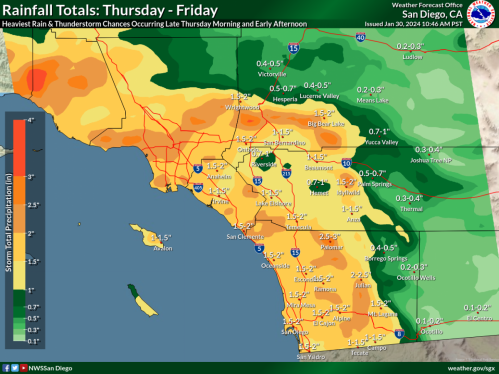
Mountain areas could get up to 10 inches of rain
UPDATE -- 4:33 a.m. Saturday-- Hurricane Hilary has sped up, with the bulk of the storm occuring on Sunday, reports @NWSSanDiego
Wind and Monday now look less severe
By Miriam Raftery
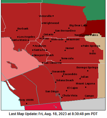
August 18, 2023 (San Diego) – For the first time ever, the National Weather Service has issued a tropical storm warning for San Diego County and neighboring counties,upgraded from a watch issued earlier today.
Hurricane Hilary has been upgraded to a category 4 hurricane with 145 mile an hour winds off the Mexican coast, and is expected to impact our region as a tropical storm bringing dangerously heavy rains, high winds, flash flooding, and conditions conducive to tornados. Flash flood watches have also been issued for Borrego Springs, El Cajon, Escondido, Julian, Lakeside, Pine Valley Poway, and coastal communities. The storm could shift, so be sure to check for updates.

Rainfall is forecast to begin Saturday, with the heaviest rains Sunday afternoon when the tropical storm reaches San Diego County. The eye of the hurricane could come within 100 miles of San Diego. The National Weather Service warns that the storm will be powerful enough to potentially weaken or wash out bridges, flood structures, close roads, cause power outages, uproot trees, and cause damage to porches, awnings, and unsecured mobile homes.
Below are highlights of warnings from the NWS for our region (the link also has details for neighboring counties):


 East County News Service


 January 8, 2025 (San Diego's East County) -- The National Weather Service has issued a red flag warning for San Diego County mountains and valleys today and tomorrow due to high winds and extreme fire danger. The strong winds that have fueled two large wildfires decimating Los Angeles County are forecast to move into San Diego County next.


 East County Wildfire & Emergency Alerts


 By Miriam Raftery


 August 29, 2023 (San Diego) -- The National Weather Service has extended the Excessive Heat Warning for the San Diego County deserts, mountains and valleys through Wednesday, August 30, at 8 p.m.. Temperatures will reach 110 to 117 degrees in the deserts, 95 to 107 in the valleys, and 90 to 100 in the mountains.
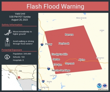 August 20, 2023 (San Diego's East County) --The National Weather Service has issued a flash flood warning now through 5 p.m. for El Cajon, La Mesa, Poway, Ramona, Alpine, Tierrasanta, Escondido, Santee, Lakeside and San Diego Country Estates. This is due to heavy rainfall capable of producing life-threatening flash floods.
Recent comments