
East County News Service
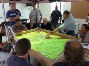
July 27, 2015 (San Diego)—How can a sandbox filled with powdered walnut shells help firefighters and property owners? It’s all part of 3-D models created by San Diego State University’s Visualization Center, which is partnering with SimTable to create modeling softare that will predict how wildfires will spread.
Researchers at SDSU project a map the powdered walnut shells, which are mounded into miniature mountains and valleys shown on the map. Then a virtual flame is lit.
Software uses information include topography, wind speed and direction, fuel type and more to predict which direction the fire will spread—and how fast, SDSU’s news center reports.
Once firefighters understand how a wildfire will spread, they can better devise strategies for fighting it. The program even allows users to simulate tactics such as water drops, bulldozing fire lines, ground crews and controlled burns to see what is most apt to work best.
SDSU is now testing how the software can be made user-friendly. Up next, SimTable and SDSU hope to create an app that firefighters can access on their mobile phones at the fire scene or on the road, helping to keep firefighters safe as they work to protect other people’s property and lives.


Recent comments