
By Ariele Johannson
NOTE: Check with the County of San Diego if you plan to attend the hearing at 9:00 a.m. on Friday, February 20th, in case the hearing is postponed. San Diego County Planning Commission meets in the COC Conference Center Hearing Room at 5520 Overland Avenue, San Diego. Phone: (858)-694-3816. Agenda changes must be made 72 hours before the hearing.
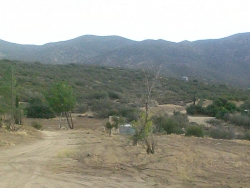
February 12, 2015 (Ranchita)—Visitors driving to the Anza-Borrego Desert on Highways S2 and S22 pass through the small community of Ranchita. The unincorporated community of Ranchita is approximately 12 miles southwest of Borrego Springs at 4,065 feet elevation. A Telecommunication Facility Major Use permit application—APPLICATION #P-11-034—has been made by Vista Towers, LLC, a company that owns and manages a number of urban and suburban sites. Its website states,“Our specialty is developing multi-carrier facilities in underserved rural areas.” The proposed Verizon and AT&T cell towers would be visible from designated Scenic Highway S22. In fact, the proposed site is only 800’-1000’ from what is called the “view shed” on roads designated as scenic highways or byways. A portion of the Pacific Crest Trail goes through this area, also.
A hearing is scheduled in San Diego at 9:00 a.m. on Friday, February 20th to review the permit application made by Vista Towers, LLC, Wireless Site Solutions.
The Ranchita Community Group for Responsible Cell Tower Siting has been in continuous communication with Planning and Development Services of San Diego County since 2012, providing research along several avenues throughout the process. This research sheds light on what the community group considers this project to be: an irresponsible siting of a large major use permit Telecommunication Facility in violation of a county ordinance regarding non-preferred zoning in a residential neighborhood. Especially problematic is that all alternate locations either have not been investigated or have been dismissed based on inaccurate representations and explanations, community members contend. Additionally, the County has been notified numerous times—through a letter from the Save Our Heritage Organization (SOHO) and historic expert Ronald May—that this Telecommunication Facility violates the California Environmental Quality Act of 1970 (CEQA) and the National Environmental Policy Act (NEPA), as it is infringing on the setting of a historic district of 1944 California adobe structures. According to the Ranchita community group, the permit application is incomplete and inaccurate both to the FCC for licensing and to the County for approval of the project. The law requires an applicant to show a significant gap in coverage in order to support approval of a major use base station in a non-preferred residential zone.
It is the County’s responsibility to properly investigate applications, and to protect communities that usually do not have the resources to go up against corporations who seek to place large-scale projects in residential neighborhoods/communities where they may be opposed. So, the RCGRCTS has been working with the County as it performs its due diligence, ensuring the process includes all community issues. Currently, several areas that require more research have been identified by the group in preparation for the February 20th hearing date.
East County Magazine has been following community opposition to this Vista Towers, LLC project. The current proposed location is on Old Mine Road, a private dirt road in a neighborhood of about 50 homes in the vicinity that would be affected by the towers. The proposed site is contiguous to property with two adobe homes that would qualify for historical significance. From these homes, the approximate physical distance to the tower site is as little as 250’ to 1000’. The cell towers could affect the area in many ways, including the setting of these 1944 historic California adobes, the view shed of the culturally significant “Montezuma Mine” that is in the hill at the end of Old Mine Road, and the view directly out of many homes. The distance of 1000’ is “well within the half mile APE (Area of Potential Effect) set by the Federal Communications Commission (FCC) and the State Historic Preservation Office (SHPO),” according to Ronald V. May, who has 24 years of experience as an Environmental Management Specialist with the County of San Diego. May has enforced California Environmental Quality Act of 1970 (CEQA) as a project manager on hundreds of specific plans, tentative maps, zoning permits, and public projects. Also, he has evaluated thousands of archaeological and historical properties using the County of San Diego procedures and criteria for historical significance, and staffed the Historical Sites Board from 1986 to 1990.
The proposed cell towers would actually hover over a cluster of 1940s historic California adobes in the area. At least five other vintage homes in the area around the proposed site qualify as to age. Two or three adobes, in particular, are well-preserved and “remarkable,” according to experts Bruce Coons, Director of Save Our Heritage Organization (SOHO), and historic expert Ronald May of Legacy 106, who have commented to the County on behalf of the Ranchita Community Group for Responsible Cell Tower Siting. As well, there are some culturally significant mines overlooking Old Mine Road: Montezuma Mine and Verruga Mine. Neither of these mines has been considered or included in either state or federal environmental reviews.
Apparently, incomplete information was submitted by Vista Towers, LLC for the NEPA, SHPO and the CEQA reviews. The fact of proximity of the 1940’s historic adobes to the project was omitted when the applicant dealt with the Historic District and CEQA AND SHPO, rendering the review process defective. The county was informed by expert Ronald May that reliance on the SHPO office assessment of historical significance is erroneous for purposes of the local zoning and CEQA issues. The standard applicable for CEQA is the local standard, which is a less strict standard than the national standard applied by SHPO. The national standard applied by SHPO as opposed to the local standard applied by the local CEQA review are two distinct processes, and one may not affect the other. A section of CEQA supports the group’s statement to the County that historic buildings don't have to be nominated or listed to receive proper CEQA review and consideration. [Note: The cost for historical designation is approximately $6500. The group objects to being asked to fund this cost for formal historical designation when the law does not require it, according to the Ranchita Community Group.]
Due to the incomplete nature of the documentation provided in the environmental reviews by the applicant, the Ranchita community group deems them defective in their current state. Also, the original proposal of a 58’ faux pine tower was changed to two 35’ faux mono-pine towers by the applicant in an attempt to mitigate the negative impact to the neighborhood. One tower is for Verizon and the other is for AT&T. However, no new public comment period was provided for this new proposal, nor a new environmental review or revisions to the MND. The group has photographs they have taken from their homes, which they believe provide the true visual effects of the proposed towers, compared to mock-ups done by Vista Towers; neighbors say these mock-ups minimize the true potential effects. The members of the community group say the images are misleading; they show specific angles that do not demonstrate how the site is viewed from the homes that would be affected. Also, the mock-up photos by the tower company do not show the four-foot-wide microwave dishes on each faux pine. The 60’ by 36’ enclosure looks much smaller than its actual dimensions.
For a history lesson on the origins of the proposed project in Ranchita, please refer to my article written in 2012, where the original photographs and other issues, such as the construction of the platform for the tower and the enclosure, are discussed in more detail: http://www.eastcountymagazine.org/ranchita-residents-reject-proposed-cell-tower.
When the resident group was first formed in 2012, one of the first items for business was the request for more appropriate sites to be considered. The Old Mine Road location is the third attempt by Vista Towers, LLC, who withdrew two prior applications because of existent protected botanical species that would be disturbed. Meanwhile, on the current proposed site on a residential property, the resident prematurely graded the site, claiming it was cleared for defensible space. This possibly illegal grading (prior to environmental studies) has removed any potential obstacles for the project in terms of protected plant species. Vista Towers has not commented on any other possible locations it is considering, however they did submit reasons for rejecting Volcan Mountain.
The main issues for concerned citizens are the following: (1.) Community character, including the preservation of the settings for the historic district and mines (2.) Proof there is a significant coverage need for the large major use permit telecommunication facility with two towers and that there is no less intrusive location or method to increase coverage (3.) Safety issues, including wildfires.
As for community character, two homes on the property next to the proposed site were built circa 1940 from native pine and indigenous adobe materials with Native American labor. Preliminary investigations on the property have been completed by Bruce Coons of Save Our Heritage Organization (SOHO) and Ronald V. May, President of Legacy 106, Historic and Archaeology Consulting in San Diego, CA. Adobe construction began in California in 1769, beginning with the mission period and the building of presidios. Adobe construction then developed with the Ranchos or the California Ranch House into a style easily recognized as California’s indigenous architecture. There were relatively few adobes built subsequent to the 1880s, being replaced by frame construction. Even fewer adobes were built during the 1940s.
Mr. Bruce Coons, Executive Director of SOHO, visited the two adobe homes on Old Mine Road and found them to be “rare examples of adobe construction during the 1940’s…which are in excellent condition and retain a very high degree of integrity.” In his letter of September 22, 2014, he writes the following concerning the two collections of adobes on Old Mine Road: These homes represent “a significant example of California’s unique heritage and is an important link in California’s architectural history. These structures more than meet the requirements for listing on California Register and the National Register of Historic Places. They must be considered as historic resources for CEQA and Section 106 and other evaluation purposes. These adobes maintain their original setting and it is import to avoid any visual impacts to their setting, feeling and association, as it would adversely impact the significance of this important historic site.” Interestingly, this SOHO letter by Bruce Coons was not included in the hearing materials posted on the County website. The county was notified of this but has yet to correct it.
Mr. Ronald V. May writes in his report, “In my professional opinion the California State Historic Preservation Officer would determine them eligible (sic) for the State National Register of Historic Properties.” May’s letter also states that the homes and other auxiliary buildings—along with others in the area—might also qualify on the National Register as belonging to the “historic district of indigenous adobe buildings erected by Native American Labor during WWII.” Due to the proximity with Old Mine Road and mines on BLM (Burea of Land Management) land in the area, there is a possible connection with the construction of these buildings. If so, that fact would establish their significance as part of the national defense effort during World War II.
Within the report, May determines that the presence of the proposed cell towers would be an alteration of the historic character of the homes, and that the cell tower project needs to be re-evaluated under 36 CFR 800.5 (a),(b) (iv.),(v.) and (f) for direct and indirect adverse effects. The setting would be seen as part of this entire property’s historical significance. The cell towers affect the setting. May’s comprehensive report goes into details, such as architectural styles, acts of Congress, and publications, such as A Field Guide to American Houses, 2002. The use of native pine posts and adobe benches on the porches and some interior roof structures in these two homes make them akin to adobes in Warner Springs built by the Native American Cupeños.
The second major issue for the RCGRCTS relates to existing cell and internet coverage in the area alleged to be served by the proposed towers. Verizon and AT&T claim the new cell tower would bring needed services to the area, including better cell coverage and internet live streaming. The RCGRCTS has questioned the veracity of this claim and states that there is no significant gap requiring such a large base station in a non-preferred residential neighborhood. The applicant asserts that coverage is non-existent, and in another location the signal is weak. The community group calls those responses “misrepresentations.” RCGRCTS believes they have verified through their own testing that there are no significant gaps in coverage for talk and video stream, though a couple of spots were light, at one end of S22 in Ranchita. Testing six homes in various locations in Ranchita found adequate voice and data coverage, including live streaming.
In the plan for better coverage, less-invasive methods for such a small area have not even been considered. These could include, but are not limited to, installation of DAS Antennae on existing electric poles and the use of solar cell towers. Verizon Corporation, at one point, did publicly commit to increasing their reliance on solar, as reported on Bloomberg News. Verizon boasts they had approximately 26 solar powered cell sites up through 2014. Unfortunately, solar apparently has not been considered, and the response to the suggestion of using DAS was dismissed for the reason that the poles in the area were not high enough. This is an inaccurate assessment. In fact, extensions can be fitted onto existing poles to facilitate the DAS equipment, and there are many utility poles right on S-22.
The third major concern covers safety issues, which further highlight that this project is not a responsible siting for a cell tower. Ever-present in the minds of backcountry residents is fire danger, as it should be for all San Diegans, since so many fires begin in backcountry areas that are prone to fires sparked by utility lines in remote and dry locations. A cell tower presents another factor in an already fire-prone area. Not only can cell towers start fires, they can fall.
Of course, timely fire response and access is a key element in keeping fires small. According to the community group, Old Mine Road is a private dirt road only 11’-14’ wide in many places as it leads up to the proposed site on private property, and is a substandard width as per the Fire Code. The community group suggests, “While it can be argued this code only applies to new subdivisions, the reason for the code is so that existing lots would not be rendered unbuildable because of a narrow road where services cannot safely enter. It was not meant to apply to an industrial/commercial Cell Tower Base Station constructed in a residential neighborhood.” In fact, property owners have already signed a petition stating they will refuse to allow their road to be subjected to and degraded by commercial vehicles. This is a private road proposed for an “industrial” use and will overburden existing easements. In the event of a fire, there could be no outlet for residents as it is a dead end road. There is also concern of flooding of the road in the winter, related to the grading that would need to be done on the mountain. Cement and asphalt would cause further run-off.
On the residential property itself at the proposed site, the Fire Code Requirements standard is for the driveway to be 20’ wide if there is more than 20% grade, as well as a turn-around space sufficient for fire vehicles. A report needs to be completed to satisfy that the property meets these requirements.
At the hearing on Friday, February 20th, the Ranchita Community Group for Responsible Cell Tower Siting sincerely hopes their concerns and the results of their untiring work will be seriously considered. The group believes alternative sites should have been explored and technology such as DAS and solar should have been seriously considered. They call for environmental reports which are based on incomplete and inaccurate information to be updated and corrected, so the Planning Commission is not relying on inaccurate and incomplete information in making important decisions entrusted to it by the communities of San Diego.
Further investigational studies and required reports, along with a more accurate compliance with the many processes involved, is of utmost importance. One of these would be an objective report by the permit applicant on the row of adobe buildings along Old Mine Road, in order to obtain a vote from the County Historical Sites Board on whether or not these buildings are eligible under County of San Diego designation guidelines. The current report submitted to the County showed only the ground examination of the construction and utility line trenching location, and failed to identify the "residential structures west" and "south" as potentially historic under either the State Register or County of San Diego historical designation procedures. Such an objective report is vital for the County to accurately determine the adverse effect of the proposed tower project on the historical setting. The community group requested the County staff to commission an independent coverage opinion, which is commonly done in these situations. The County chose not to comply with the community group’s request. An investigation into actual cell coverage is also needed for cell phones and internet streaming, since the existing coverage report by the applicant differs significantly from actual tests and usage reports by many other Ranchita residents.
The critical issues of historical significance of the adobes and mines in the area, accurate findings related to coverage, and safety concerns need to be addressed in greater detail in order for the Planning Commission to take an informed vote. Besides the potential consequences for any individuals or families who might face from a similar challenge in their neighborhoods, these lands are some of the last virgin wilderness in San Diego County. Everyone benefits from having them preserved, as well as future generations. Certainly, communities need to be protected from potential future wildfires and loss of irreplaceable historic treasures and landscapes, not to mention other safety issues related to cell towers.
The following was copied from the calendar for Planning Commission of San Diego County for February 20, 2015. The hearing for the project is #3 on the agenda, which begins at 9:00 a.m.:
Old Mine Road Wireless Telecommunication Facility Major Use Permit: PDS2011-3300-11-034; North Mountain Subregional Plan Area (Smith)
The applicant requests a Major Use Permit for an unmanned wireless telecommunication facility consisting of two wireless carriers, Verizon and AT&T, using two 35-foot tall faux mono-pine trees. The faux tree to be leased by Verizon would be mounted with 12 panel antennas and one microwave antenna. The faux tree to be leased by AT&T would be mounted with eight panel antennas and one microwave antenna. Both faux trees, associated equipment, and an emergency generator would be located within a new 38-foot long by 63-foot wide concrete masonry unit enclosure, which varies in height between six feet, eight inches to 10 feet, depending on the topography. The property is currently developed with a single-family home and accessory structures. A Mitigated Negative Declaration (MND) has been prepared for the project pursuant to the State California Environmental Quality Act Guidelines, and is part of the action. The site is subject to the General Plan Designation Rural Lands (RL-40), and Zoning for the site is Limited Agricultural (A70). The project site is located at 27865 Old Mine Road, in the North Mountain Subregional Plan Area, within unincorporated San Diego County (APN 196-060-12).


Recent comments