
 By Miriam Raftery
January 31, 2024 (San Diego)—On the heels of last week’s severe storm, another atmospheric river is moving into our region, bringing widespread rain, mountain snow as low as 3,500 feet, gusty winds, cold temperatures and possible thunderstorms. A flood watch has been issued by the National Weather Service for Thursday morning through Friday morning for San Diego County’s mountains, deserts and valleys, with potential for flooding in some urban and low-lying areas as well as along rivers and streams.
The NWS has also issued a wind advisory for valley areas, a high surf and small craft advisory for coastal areas where waves could reach 10 feet.
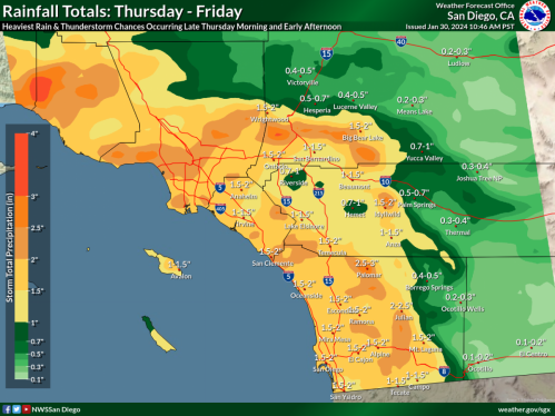
Mountains and foothills have a 60% chance of 2-4 inches, a 10% chance of 4-6 inches, and a 5% chance of over 6 inches of precipitation. Deserts could receive as much as 2 or more inches of rain, with .5 to 1 inch likely. Valleys and coastal areas have a50%chance of 1-2 inches, a 40% chance of 2-3 inches,and a 5% chance of over 4 inches.
 Wind gusts up to 45 miles per hour could have potential to damage trees, outdoor property and unsecured objects. Heavy snow may bring power outages and difficult travel at higher elevations. Gale conditions working their way down the coast bring rough seas hazardous for boating.
Rainfall will taper off to light showers over the weekend, with yet another storm will bring more wet weather next week.
Sand and bags are available at most sandbags; bring a shovel to fill bags.


Recent comments